
|

| . | Estuarine Landscape |
| Essay first published in 'Topos' June 2011 |
While the Thames estuary 'proper' lies to the east of the city, the river's tidal reach extends far upstream, into central London and beyond. Since 1984 central London has been protected from the threat of tidal surge by the Thames barrier. This protective barrier has been used with increasing frequency over the intervening years. The areas most at risk from tidal flooding are not always those closest to the open sea. Threats exist throughout the river system, including at the upper limits of the tidal reach, where there is regular flooding of inhabited islands and river-side settlements.
The most extreme tidal conditions are caused by a combination of the high tidal ranges that occur at the spring and autumn equinoxes, and high winds in the north sea out beyond the mouth of the estuary. Historically these conditions have caused major flooding, most recently in 1953. During surge conditions the Thames Barrier is raised to block the passage of excess volumes of sea water from reaching the upper tidal reaches. The Thames in west London not only has to contend with tidal loadings but also, in storm conditions, with significant fluvial and surface water loadings. Heavy rains in the catchments of the Thames valley result in massive volumes of water passing down the river channel. These volumes are then further loaded with surface water run-off from the local urban catchments within London. Closing the Thames barrier, whilst offering protection against tidal surge, also has the effect of creating a back-up of fluvial and surface water within the river channel. Climate change modelling predicts that these conditions will grow worse over the next decades. [1]
The Thames tributaries within the tidal zone can be divided into those which are tidal and those which are non-tidal. Tidal tributaries include the rivers Lee, Roding and Darent. The tidal tributaries downstream of the Thames Barrier are equipped with their own mechanical flood barriers which can closed during tidal surge conditions. The non-tidal tributaries in the East of London, such as the Goresbrook, the Beam and the Ingrebourne, are provided with tidal valves at the point where they meet the Thames. These "locked" tributaries can therefore only discharge to the Thames for a period either side of low tide. This can give rise to serious flooding problems to the land-side of the Thames river wall at such times as the tributaries are full and tide levels are raised, as they are during conditions of tidal surge.
The primary tool of hydrological modelling is volumetric analysis. The prediction of flood events relies firstly on identifying the volumes of water being added to any given system under certain weather conditions, and secondly in predicting how this water will be distributed spatially over time. These predictions are supported by the use of increasingly accurate satellite data for topographic description, coupled with projections for climate change and consequent increased potential for individual storm events. These techniques result in highly abstracted forms of description, in which complex digital modelling is combined with risk theory to predict a series of theoretical scenarios ranging from the benign to the apocalyptic.
Our current cultural and political horizon expects that these forms of abstract modelling and risk prediction should be taken as a key prompt in the planning of investment in flood management infrastructure. Given the large scale engineering typically involved in these schemes the cost of this investment is measured in multimillions of pounds. One of the major studies undertaken in recent years by the United Kingdom Environment Agency is titled Thames 2100. Thames 2100 sets out to define a strategy for action on flood risk for the tidal Thames looking forward over the next 100 years. This kind of long term planning raises a fundamental question; How far can we be sensibly plan ahead for these types of circumstance, and to what extent should we be attempting to predict necessary actions for a time 60 years hence? The consideration of tidal flood threat needs to balance the infrastructure of protection with the support of existing habitats and ecologies of the estuary. It may be that the uncertainties and risks that pertain to the most vulnerable sections of the Thames floodplain might best be addressed through a new contingency; a strategy based on impermanence, and meanwhile uses within those areas at most risk.
The construction of man-made sea walls in the outer estuary dates back at least to the middle ages and very likely much earlier. The first sea defences were of earth construction, based on a reworking of the natural profile of the land. Local clays and silts were excavated to form a delph ditch or borrowdyke with the raised embankment to the seaward side of the ditch. The purpose of these embankments was less for the protection of settlements than to allow better use of the enclosed land for the grazing of livestock. Traditionally the protected marshland established through the creation of these sea defences has been used for grazing by both cattle and sheep, cattle predominantly in the summer months. Hydrologically the effect of the embankments is to create brackish or near-freshwater conditions on the land-side, which, together with the regular regime of grazing, has resulted in a series of valuable, if highly artificial habitats. Fragments of the old salt marsh structure can still be seen to the land side of these sea walls in the form of irregular dykes and fleets. Rare plants such as brackish water crowfoot and soft hornwort can be found here, part of the wider ecological matrix of the coastal fringe. Bird species such as redshank, shelduck and skylarks thrive on the open marshland.
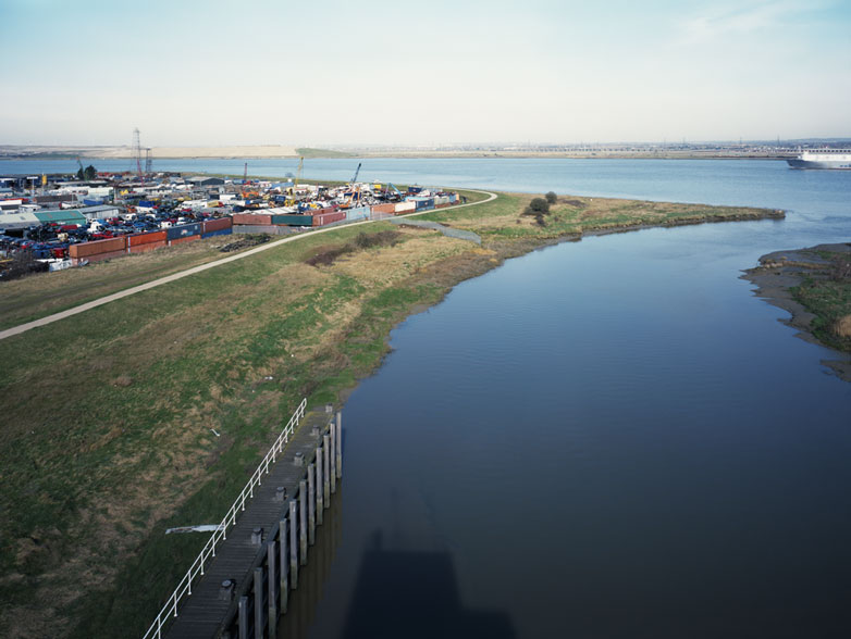
There are few traces of this primary form of earthwork sea defence on the inner reaches of the estuary, although there are traces of timber revetments, superseded in modern times by hard engineered structures of concrete and sheet steel [2]. However we can well imagine that the 12th century monastic community of Lesnes Abbey in it's development of Erith marshes, used a simple form of earth embankment to secure the Abbey's grazing lands from regular tidal flood. On the north bank of the river at Rainham, regular grazing of the marsh ceased some decades ago and since then the landscape has been left largely unmanaged. Uncertainties over future land-use and speculative plans to create new urban development within the floodplain resulted in an unplanned and informal fallow condition of landscape. The reinstatement of traditional grazing, due to take place later this year, will serve to reclaim the habitats which led to Rainham marsh's designation as part of the Inner Thames Marshes Site of Special Scientific Interest, and return the land to a form of management which has likely been in place for the best part of a thousand years.
The silt lagoons at Rainham, which date from the 1960's, reverse the division of fresh from salt water which was set in place by the original medieval embankments that isolated the marshland from the tidal waters of the Thames. The lagoons were constructed directly on top of the former grazing marsh as a stockpile for dredged material taken from the navigable channel of the river. In this process of deposition, which is still active, dredged material is mixed with brackish river water to allow its pumped transfer through steel pipework on to the lagoons half a mile inland. This artificial process has the effect of mimicking the conditions of salt marsh and tidal mudflats, creating, as an accidental happenstance, a new saline landscape, as important as the neighbouring grazing landscape to the nature conservation designations of the marsh.
In the outer estuary the soft earth banks which still form much of the 500 miles of sea defence are also recognised for the unique habitats that they support. The grasslands which cap them host nationally rare plant species such as least lettuce and sea club-rush, together with meadow brown and essex skipper butterflies. However the integrity of these embankments, and the habitats they support, are increasingly threatened by the encroachment of the sea through a combination of falling land levels and the anticipated effects of climate change. The intertidal habitats of the estuary are dependent on the foreshore mudflats and salt-marsh on the marine side of the tidal defences. As these intertidal zones become increasingly swamped, the soft engineered embankments become more exposed to the forces of coastal erosion. One strategy adopted to replace these lost habitats is that of managed retreat. This has been effected in a number of locations in recent years, notably at Northey Island and Tollesbury in Essex. In this strategy the sea walls are breached, allowing the sea to reclaim the freshwater grazing marsh, and establish the fully saline habitats of a natural salt-marsh.
It has been argued that if a similar strategy of managed retreat were to be adopted on the inner reaches of the estuary, the resulting open landscapes could alleviate the problem of tidal surge by offering what would be, in effect, saline reservoirs to receive the excess volumes of water present in the river corridor under tidal flood conditions. Arguing against this proposal is firstly, the desire to retain the freshwater wetland and wet grassland habitats that have developed to the land-side of these sea walls, and secondly, a recognition that retreat on sites within the more settled landscapes in the inner reaches of the estuary would require the construction of many tens of miles of new flood walls to protect existing areas of built settlement and the relocation of significant elements of existing urban infrastructure. Having considered the option of a form of inner estuary managed retreat as a means to address the risks to London from tidal surge, the Thames 2100 study now seems to have largely discounted this as a practical scenario.
What are then the future options and opportunities given this complex context? One practical action could be the repair of sea walls in the inner estuary in a form that offers the potential for a reinstatement of the intertidal habitats currently at risk through encroachment. This could be effected through techniques of re-profiling and the substitution of hard engineering with soft engineering strategies. A second action could be to create highly localised events of managed retreat, establishing new pocket landscapes allied to the saline estuary which take their prompts from, and respond to, natural and historic features. This might include, for example, the development of foreshore elements associated with the creek outfalls, such as Frog Island at the mouth of Rainham Creek, or at Aveley Bay at the outfall of Wennington Creek. Similar opportunities might be found at the mouth of the river Darent and along the Erith foreshore.
Current works on the Inner Thames Marshes to the north and south of the river have begun a process of restatement of these open landscapes to support better surface water flood management, enhanced wildlife habitats and public access. At Erith re-profiling of dykes and culvert clearance has created better conditions for free flow of surface water and enhanced habitats. Next to the housing estate at Thamesmead, the blank open spaces of the modernist parkland originally laid out in the 1970's have been enclosed to form new grazing paddocks.
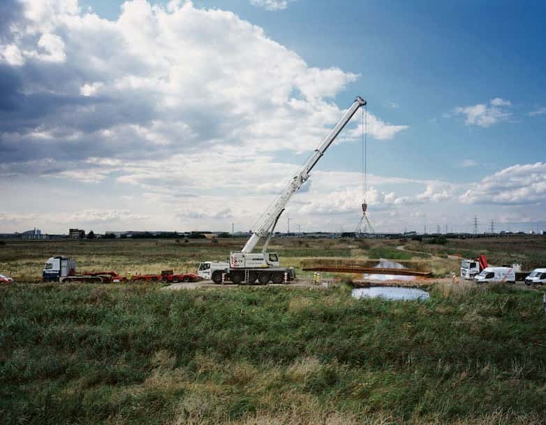
On the north side of the river a new series of public access paths and infrastructural links is set to restore the historic link between Rainham village and the Thames. This will include a new riverside park with future plans for a cafe on the site of the old public house and tea rooms, the Three Crowns. Alongside this renewed access, the project will also provide farm management infrastructure to support the reintroduction of livestock to the marsh. Hydrologically this section of the marsh acts as a balancing store for surface water to be held during conditions of high tide when the tidal valve at the river wall is closed. New ditches and reed beds created within the landscape by adjustment of ground levels will offer much enhanced wetland habitats and allow better performance of this hydrological role.
Other projects have yet to be fully explored. One opportunity which could be seen to be directly linked to the narratives of the tidal estuary is that of the future landscape development of the silt lagoons: the periodic discharge of saline silts on the lagoons described above could potentially be augmented by use of wind pumps, allowing a more regular artificial tidal wash of saline waters taken from the Thames. Coupled with targeted local excavation a new virtual saltmarsh landscape could be created recovering the wildlife habitats that have been lost by the recent reductions in use of the lagoons by the Port of London Authority.
The Inner Thames Marshes share characteristics with the rest of the estuary. As an experience they have a rawness and immediacy which is bound up with their role as a working landscape of infrastructure and industry. The opportunities safeguarded as the result of planning policy which ruled out new urban development should not be taken forward as a creeping suburbanisation of this landscape. Those characteristics of experience and use which link London's 'local' marshes to the wider estuarine landscapes should be recognised, and we should seek to value and support their qualities of wilderness, happenstance, contingency and flux.
